

In this episode of Sailing A B Sea we explain why this wasn't part of the plan and that sometimes you have to work with what you've got. Anchoring here... We...
Closed Captions (CC):
You can make as many plans as you want
on a boat but sometimes when you get
there you find that the bays are already
full with other yachts, the forces of
nature working against you and you end
up somewhere where you didn't think you
were going to be. Where should we be?
Fourni. Where are we?
Patmos. It's a nice place though!
We've just spent the last three weeks
doing this, working on our computers in
the summer office of Sailing A B Sea and
it's not a bad office I'm gonna be fair
with you, we've got cold beer downstairs
we've got a great view whichever way we
look here, oh and cold wine of course but
the reason why we've been working non-
stop for three weeks is because we
wanted to buy some time and Aannsha's
just working on a final video which will
mean that we've bought ourselves
approximately five to six weeks of time.
They're all uploaded, they're all done
they're all completed, they're all
scheduled for release and that means as
soon as the wind starts blowing in the
right direction we can then go off on a
sailing adventure and just chill out relax
because that's what this is all about
really. Not sitting in front of computers
every day.
My eyes are like this
We're in Patmos and we left
Pythagoria in Samos at 10:30 a.m.
yesterday hoping to go to Fourni
Yeah let that one go
Yeah, it wasn't too bad the wind was with us
most of the way and at one point we
actually got eight knots of speed, yeah
At one point we actually got I think 27
knots of wind, yeah, it was pretty good
yeah, maximum 30 gusts every now and then,
yeah. Well we got two Fourni, we did, and
there are several little bays that we
could have anchored in if everything was
going well. A couple of them were already
full and one of them had bad holding
didn't it? Yeah we tried to drop the
mantus twice but it obviously was very thin
sand over rock so it just dragged and of
course the wind was still blowing at 25
knots at that point. Yes it was. So it was getting a
bit hairy yeah getting pushed around
while getting the anchor back up yeah and had the potential to push us into some
other boats in there so we ditched that
cove went to another cove. Yeah another
little cove which actually looked like
really nice place to stop and it had
cemented posts that were on the side of
the coast yeah so you could actually do
stern to and then swimming across and
tying a line ashore. But 25-knot winds was
coming right on the on the backside so
yes would have blown us before Aannsha
would have had a chance to get a line
ashore (from the anchor) we'd have been all over the
place. Yeah, so it was just not possible
so we actually sailed across the cut
which is where the wind tunnels down which wasn't actually that bad.
Well it was still gusting to 30 there - hoping that one
of the little bays that we saw on the
chart plotter would be good holding. But
that turned out to be all rock so at
this point we're losing light - around
about 5.30-5.50pm we ended up making a
decision because we had no options left
really except go back to Samos which would have taken hours
So the decision was made to come to Patmos
which was only a two-hour trip away, yes
And of course the wind which had been
blowing like billy-o all day...
We got the headsail full out we were all gonna to go whoosh ... Nope! The
wind decides it's giving up for the day,
it's done its job, it's going home - yes. So
we had some motor because we needed to
reach this anchorage before it got dark
because you know one thing I certainly
don't want to do is come into an unknown
anchorage in the darkness. So we got here
with about an hour's daylight left yeah and dropped
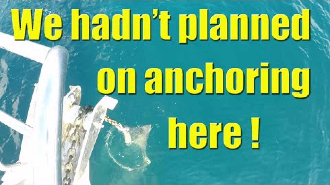
anchor in this nice little day here we're in sick
meters of water, it's very clear water, the
bottom is sand with some weed patches
but the Mantus just went straight in and
boom! Wasn't that a relief? It was. That was
about eight o'clock at night. So it was
quite a long day for us actually. It was a
huge day. Yeah and it was an adventure
chock-full of different scenarios that
we hadn't expected... which is why we doing this. Yeah
So of course Patmos is further south
than we anticipated we were gonna go at
this stage of the journey because really
we wanted to head west and slightly
north so we've sat down this morning
with Google Earth, the pilot guidebook
and also the chart plotter and mapped
out roughly where we're gonna go next
which surprisingly is a little bit south
again. A little bit South but also West
Mmm, but the direction that we're going
to go in is going to open up a lot of
islands for us. Yeah, so it feels like a
really good choice yes doesn't it and I
think the biggest hop we've gotten is
like 26 miles, which we like the idea of. That's
easy to do, because as well that means
that if one anchorage is full then we
haven't got far to go before you know we
can find somewhere else
sort of thing so. Leave early enough
in the morning and you still leave
yourself plenty of daylight hours. Yes. So
today I'm gonna download footage from
the cameras, recharge all the batteries
because already our batteries on the
boat are full and we are producing much
more power than we need from our solar
array. So we're gonna get hot water. We've
already got hot water. Basically just make sure
that when we're ready to move everything's good to go
It's a nice little bay. I'm happy
that we actually found here, I mean it
seems to me that, you know, the universe
has got better plans than we had. Time to
chill out I think. Yeah
From 30-knot
winds just a day ago we've woken up to
this this morning almost zero wind, just
a light breeze but dead calm seas, dead
flat, really really comfortable to sleep
when it's like this.
Now how many of you are old enough to
remember a kids TV cartoon from 1971
called the Hair Bear Bunch? I do I think
it was probably about nine years old at
the time. I think with my hair at the
moment I qualify for a leading role if
they ever decide to bring back the Hair
Bear Bunch. But today we're going to fix
that. Just over here off our starboard
side is a small cove and we're going to
take the dinghy over there and Aannsha's
going to turn it into a hairdressing
studio so I look fabulous again
Well this is probably one of the most
interesting places I've ever had a
haircut. Thank you. You're welcome!
Quite a few of our regular viewers have
asked us to explain how we go about
passage planning, so I think we'll use
the Greek island of Amorgos in the
example here. The first place we look is
the pilot book and in our case it's the
Greek Waters Pilot book and we're
looking at the island of Amorgos
and so we read all the information that
the author has given us on the island
itself, the approaches, mooring facilities
and all the different anchorages and
then we work out which one that is our
preferred anchorage. In this case it's
Katapola because it's got the best
holding and he's even got a photograph
of it here and then we also chose two
other anchorages, Plan B and Plan C just
in case Katapola was full or it didn't
turn out to be what we expected. Our
Greek Waters Pilot book is quite old but
the essential information that we
require from it really never changes.
These are things like, what is the bottom
is it mud, is it sand, is it weed? Are
there any obstructions? What is the
prevailing wind? And are there any
submerged rocks or reefs that we should
look out for? Of course it does mean that
the facilities that are reported in the
book are usually a pleasant surprise
when we get there because they've been
upgraded since the book was written.
After gathering all the information we
can from the pilot book we then go and
have a look at our chart plotter because
it is the most up-to-date information we
have on the area that we're planning on
anchoring. This is basically just to
cross-reference the information that we
found in the pilot book and make sure
that nothing major or dramatic has
changed. Generally the chart plotter also
contains photos of the area we're
thinking of anchoring in which is very
helpful and it gives us the water depth
at the anchorage of choice. Depending on
the details of the information it may
also tell us what the bottom is. The
prevailing winds for the time of year
that you're visiting also play an
important part in choice of anchorage
Throughout the summer months here in the
Aegean Sea the Meltemi is the wind
that we have to take most consideration
of and it generally blows from the north
northwest or northeast,
depending on exactly where you are in
the sea. Once we've decided on our plan A,
B and C for preferred anchorages, we put
those waypoints into the chart plotter
and then we head back down below to the
computer and open up Google Earth. In
here we can actually see the most recent
aerial photographs of the preferred
anchorages and we also get to plot out
exactly which path we're going to take
to get there. This gives us the distance
in nautical miles and from that we can
generally estimate how long it's going
to take us to get there
based on five knots of speed. The final
thing we look at are the wind prediction
websites. We use Windy and PredictWind
In particular we're looking for wind
direction, wind strength and also the
predicted gusts. Based on what we see
here we are the go or we don't go and
that's generally how we plan our
passages while we are here in the
Mediterranean Sea.
Good morning people it is Friday
and we've just up anchor to
try and get another anchorage closer to
town because we wanted to grab some
internet, we're having internet issues
again. The solution we thought we had
is not working out because of rules of
regulations and small print and we'll get
around to that.
So we went into a little bay back there. The mantus just would not go in so we've
decided that we're going to another island
where we're actually going to anchor in
the big bay right next to the town and
that will allow us to put the dinghy in and
dinghy over to town and look for a Greek
Cosmote store to get internet data... mmm
Where are we going was it Lipsi? It's
not too far, we are sailing, we're doing
six knots at the moment which is nice.
It's pretty good isn't? Pretty good - yeah with 17
knots of wind. Sweet
Time of arrival 1:30 - then we're gonna
put the dinghy in, yeah, then we'll head
over to the little town, yeah, and see if
we can find somewhere to buy some
data for our internet. Yes coz we're
running very very low. Yes. I'm gonna do
this Ship's Log now. Okay. See you soon.
Well we did think we had the
internet all sorted and done and dusted
but unfortunately the fine print reads
that with ''3' from the UK the SIM card
even though we're paying for a hundred
gigabytes of data per month when you use
the SIM card overseas you can only
access 19 gigabytes of data per month and
you can only be using it in Europe for
four months out of the year. Internet woes.
I'm sure every yachty has them but of
course when you work on the internet
like we do then you really need a lot of
data. There's got to be a solution out
there somewhere. There's got to be.
Next week
on Sailing A B Sea, our mission to find
Internet data takes us over hill and
dale. If you've enjoyed this video
go on, give us a like and if you haven't
already subscribe and ding that bell
icon so that you get notified of future
videos and if you really want to help us
out share this video with your friends
you
Uploaded by:
Sailing A B Sea
•
Category:
Sailing, General Vlogs
•
Added on
27 July 2019
•
Location:
Patmos, Greece
Description
In this episode of Sailing A B Sea we explain why this wasn't part of the plan and that sometimes you have to work with what you've got. Anchoring here... We...
Closed Captions (CC):
You can make as many plans as you want
on a boat but sometimes when you get
there you find that the bays...
Closed Captions (CC):
You can make as many plans as you want
on a boat but sometimes when you get
there you find that the bays...